Fireline upgrades in protected areas south of Brisbane
 Open larger image
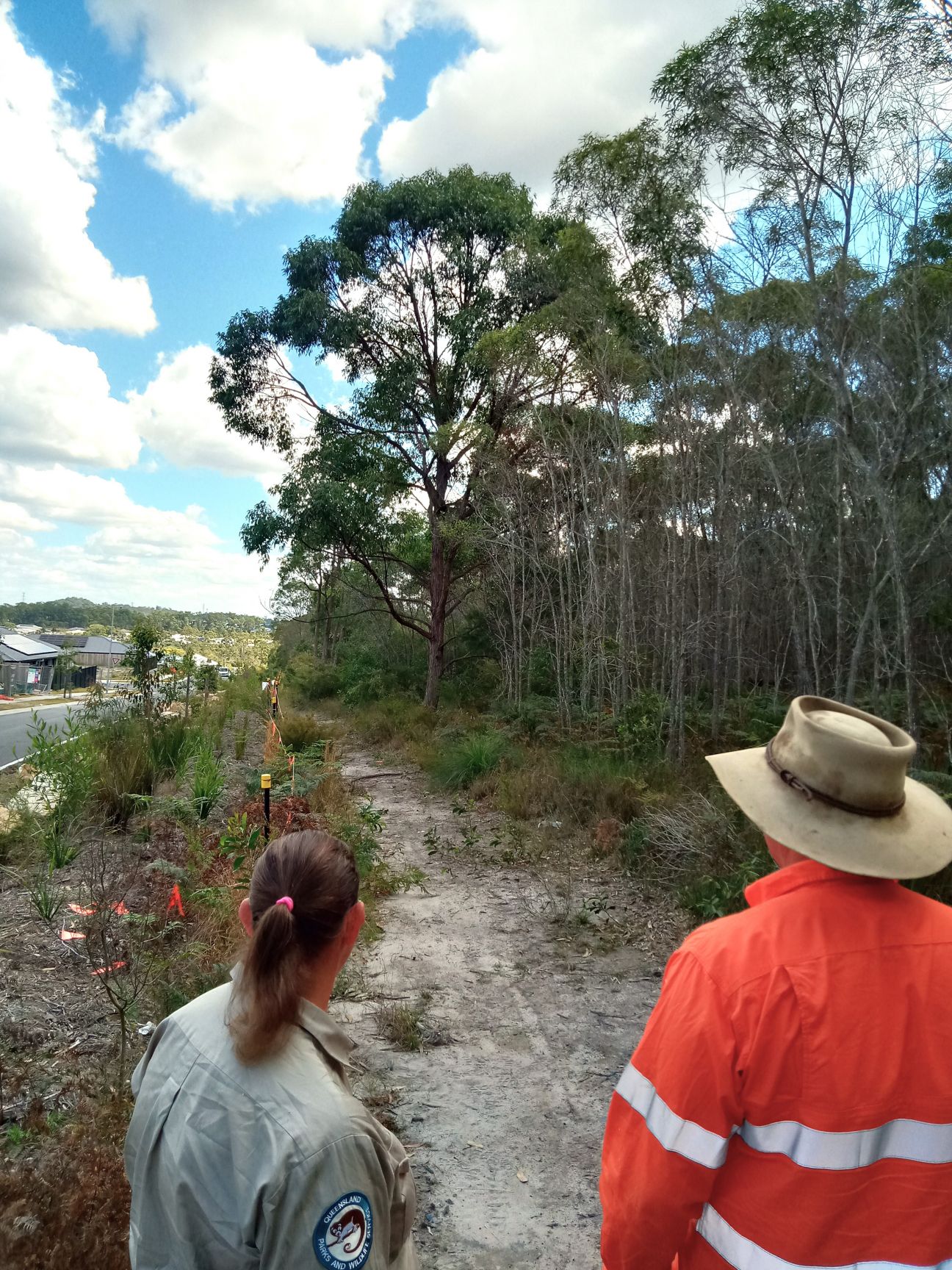
Planning of a fireline upgrade.
Queensland Parks and Wildlife Service (QPWS) will be upgrading firelines along several boundaries in protected areas south of Brisbane between July 2026 and June 2028. These areas are:
- Daisy Hill Conservation Park
- Plunkett Conservation Park
- Buccan Conservation Park
- Carbrook Wetlands Conservation Parks 1 and 2
- Wolffdene section of Edward Corbould Nature Refuge.
QPWS and the Queensland Fire Department have identified these areas as urban interface locations where bushfire risk mitigation is a priority.
To address this, QPWS will undertake vegetation management and earthworks along existing firelines and/or near the park and reserve boundaries. These works aim to:
- mitigate bushfire risk to life and property
- assist in managing fuel loads in areas adjacent to private properties by supporting planned burning and other mitigation activities
- improve access for firefighting vehicles and firefighter safety
- enhance the function and service life of firelines.
QPWS will be engaging contractors to undertake the works involving:
- fireline widening, which may involve removing vegetation along park and reserve boundaries and adjacent to firelines
- addressing poor drainage by adding rock to improve vehicle access.
Firelines are typically established at widths of 4 to 10 metres, depending on the surrounding vegetation and topography. Vegetation that is mulched or felled and cut up will be disbursed onsite to minimise the spread of pests and diseases.
The works will occur between July 2026 and June 2028. Neighbours will be informed before works commence and the information will also be published on the Parks and forests – Park alerts page for Daisy Hill Conservation Park and Plunkett Conservation Park and Wickham National Park.
Community information sessions will be held by QPWS and Queensland Fire Department and will be promoted on the department’s website. QPWS will undertake the following actions at least 4 weeks before the planned start date:
- distribute flyers to adjoining property holders
- post signs at the main entrance to the park and at the proposed work sites
- post a Park alert on the department’s website.
Please refer to the maps of works section for locations and further details on the works for each fireline upgrade, which will include installing new boundary fencing in some areas.
Mitigation of environmental and cultural heritage impacts
Environmental Impact Assessments have been completed for all proposed works.
In areas of only vegetation management works:
- regrowth vegetation, including identified hazardous trees, will be removed and stumps ground
- large habitat trees will be retained where possible
- vegetation within 10–20m of all watercourses, gullies or wet areas will generally be retained
- an independent fauna (wildlife) spotter will be engaged for all vegetation management works. The wildlife spotter will:
- inspect the area approximately one–two weeks prior to the commencement of works to develop a mitigation strategy if necessary
- be on-site while operations are underway
- relocate wildlife that may be impacted by works to a suitable surrounding area in consultation with QPWS staff.
Where it has been necessary to remove larger regrowth trees to widen firelines, QPWS will be installing habitat hollows and boxes for wildlife.
Aboriginal Cultural Heritage Assessments will be undertaken in conjunction with the relevant First Nations group during the planning phase of the project. Cultural monitors will be engaged during earthworks along identified firelines to record any discovery of cultural heritage material.
Impacts to park users and adjacent residents
The nominated boundary firelines within the protected areas will be closed for safety reasons while works are being undertaken. Other sections within the parks will remain open to the public.
QPWS will take reasonable steps to minimise any temporary impacts associated with the works.
To mitigate noise and dust, the contractor will only conduct works:
- between 7am and 4pm Monday to Friday
- in only one zone at a time within each protected area
- ensure any dust created is kept to a minimum—this may involve the use of water trucks when necessary.
Each fireline upgrade will take up to three weeks to complete, depending on weather conditions, vegetation type, and any unforeseen operational issues.
If you have any concerns about these works, please contact us through one of our Feedback forms. Please mark your enquiry ‘SEQR DHUI Stage 2 project’.
Maps of works
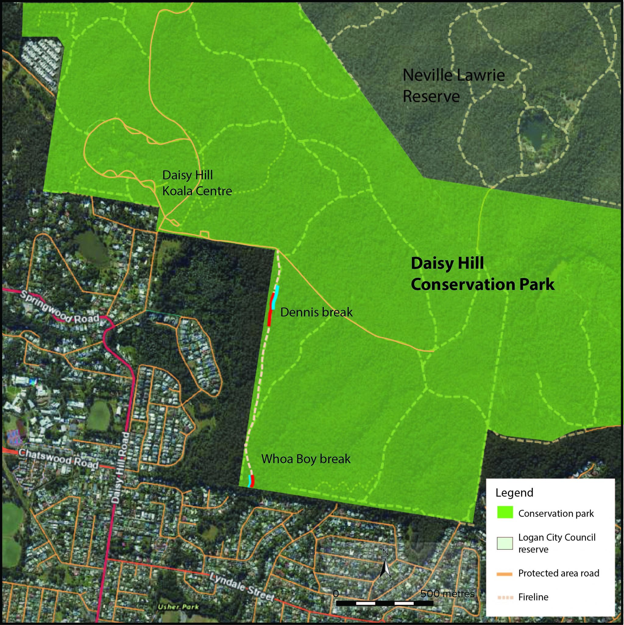
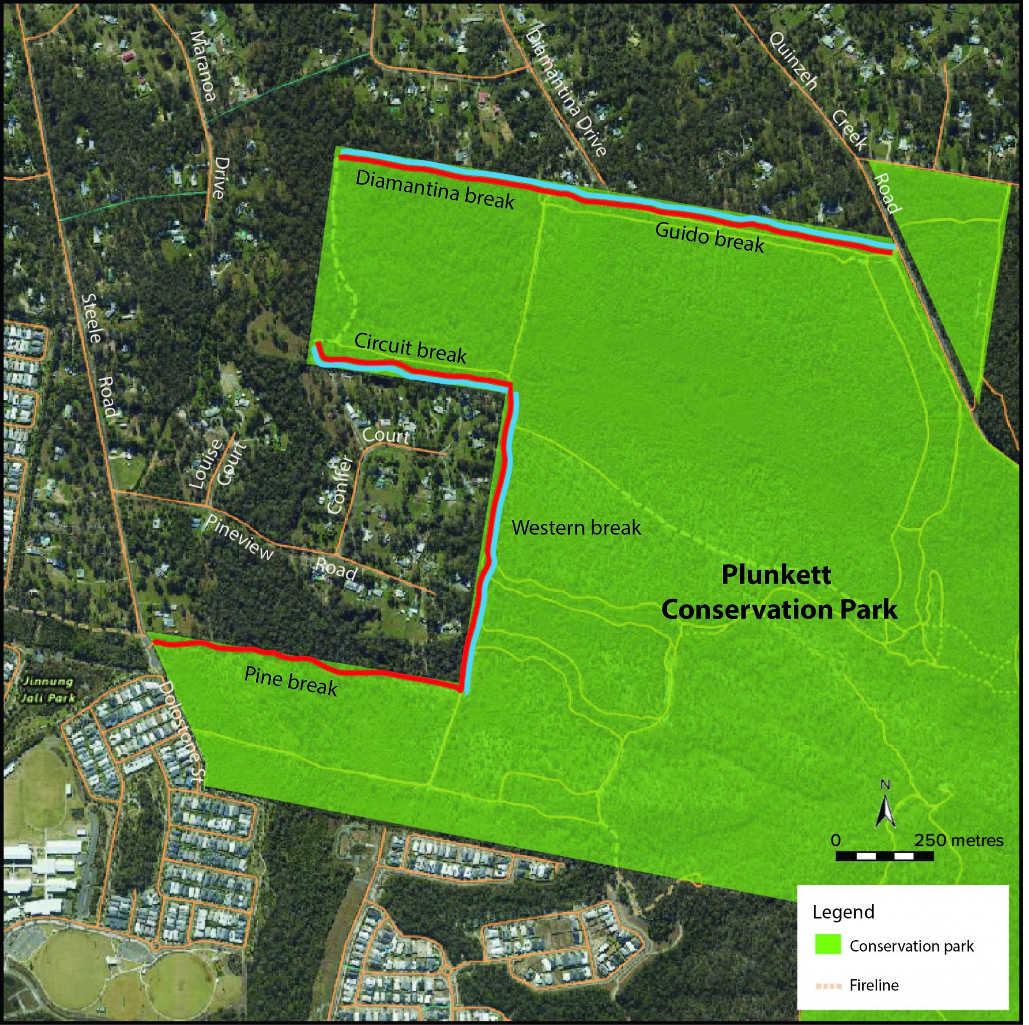
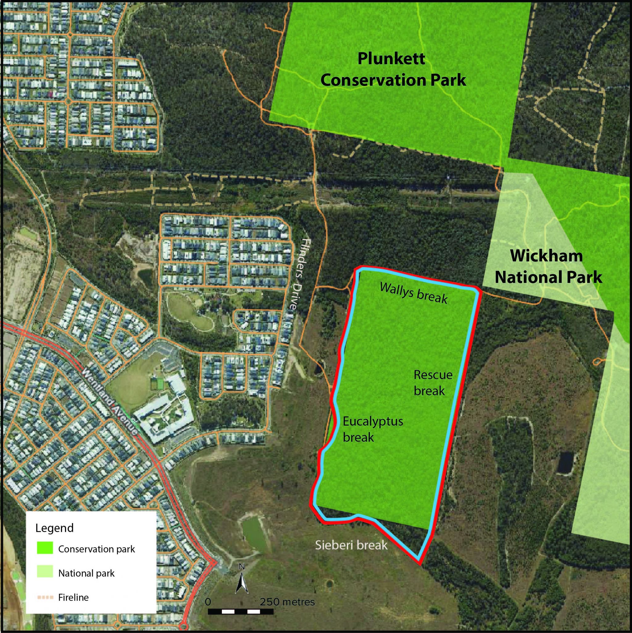
- Thick blue lines are work areas requiring vegetation management.
- Thick red lines are areas where firelines or vehicle passing areas will be constructed.
Removal of understorey vegetation means removal of all vegetation below 350mm at chest height (including ground cover).
View maps:
- Daisy Hill Conservation Park
- Plunkett Conservation Park
- Buccan Conservation Park
- Carbrook Wetlands Conservation Parks 1 and 2
- Wolffdene section of Edward Corbould Nature Refuge.
Daisy Hill Conservation Park
 Open larger image
Daisy Hill Conservation Park map with fireline upgrades indicated.
- Dennis break—upgrade approximately 180m.
Earthworks: Repair erosion and wheel ruts by hardening with rocks and reinstate and improve drainage where required.
Vegetation management: Minor vegetation clearing and fireline widening of approximately 80m. - Whoa Boy break—upgrade approximately 40m.
Earthworks: Repair washouts and wheel ruts and reinstate drainage.
Vegetation management: Widen break and remove understorey regrowth and weeds.
Plunkett Conservation Park
 Open larger image
Plunkett Conservation Park map with fireline upgrades indicated.
- Pine break—upgrade approximately 689m.
Earthworks: repair wheel ruts and installing whoa boys, formalising drains and rock hardening of creek crossing and wet areas.
Vegetation management: Nil. - Western break—upgrade approximately 681m.
Earthworks: minor hardening (approximately 350m) and improve drainage.
Vegetation management: minor vegetation encroachment removal required to widen fireline. - Circuit break—upgrade approximately 470m.
Earthworks: minor wheel rutting requiring screeding.
Vegetation management: minor regrowth vegetation removal required. - Diamantina break—upgrade approximately 470m.
Earthworks: install whoa boys to improve drainage.
Vegetation management: widen fireline by slashing and mulching minor regrowth vegetation. - Guido break—upgrade approximately 810m.
Earthworks: approximately 500m of the fireline requires formation of whoa boys to improve drainage.
Vegetation management: widen the break by removing minor vegetation as required.
Wallys block in Plunkett Conservation Park
 Open larger image
Plunkett Conservation Park map (Wallys block) with fireline upgrades indicated.
- Eucalyptus break—upgrade approximately 900m.
Earthworks: fireline surface hardening and improve drainage.
Vegetation management: remove regrowth vegetation, including stump grinding.
Install approximately 850m of boundary fencing. - Sieberi break—upgrade approximately 429m.
Earthworks: fireline surface hardening and improve drainage.
Vegetation management: slashing understorey and removal of larger regrowth vegetation, including stump grinding.
Install approximately 429m of boundary fencing. - Rescue break—upgrade approximately 930m.
Earthworks: track surface hardening and improve drainage.
Vegetation management: slashing understorey and removal of larger regrowth vegetation, including stump grinding.
Install approximately 928m of boundary fencing. - Wallys access—upgrade approximately 410m.
Earthworks: improve drainage.
Vegetation management: mulching of understorey and removal of larger regrowth vegetation, including stump grinding.
Install approximately 410m of boundary fencing.
Buccan Conservation Park
 Open larger image
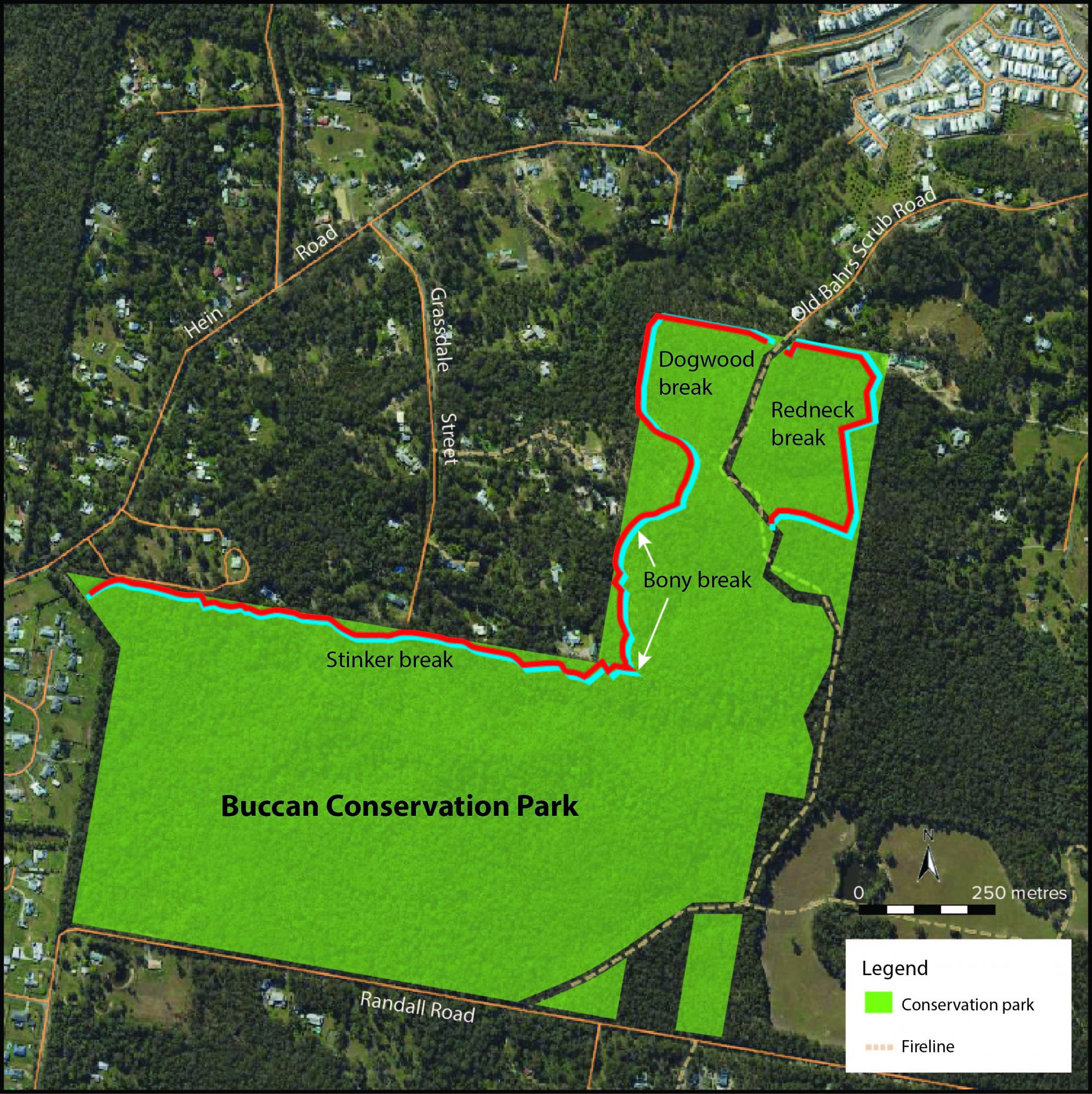
Buccan Conservation Park map with fireline upgrades indicated.
- Stinker break—upgrade approximately 2086m.
Earthworks: repair washouts and drains along the creek crossing section.
Vegetation management: mulching understorey and removing approximately 700m of regrowth vegetation, including stump grinding. - Bony break—upgrade approximately 290m.
Earthworks: repair washouts and wheel ruts.
Vegetation management: mulch regrowth vegetation. - Dogwood break—upgrade approximately 430m.
Earthworks: screeding of the fireline, installation of whoa boys and improving drainage.
Vegetation management: mulching understorey and removing of regrowth vegetation, including stump grinding.
Install approximately 495m of boundary fencing. - Redneck break—upgrade approximately 840m.
Earthworks: install whoa boys and reinstate drainage and screeding of track.
Vegetation management: mulching understorey and removing of regrowth vegetation, including stump grinding.
Install approximately 605m of boundary fencing.
Carbrook Wetlands Conservation Park (1 and 2)
 Open larger image
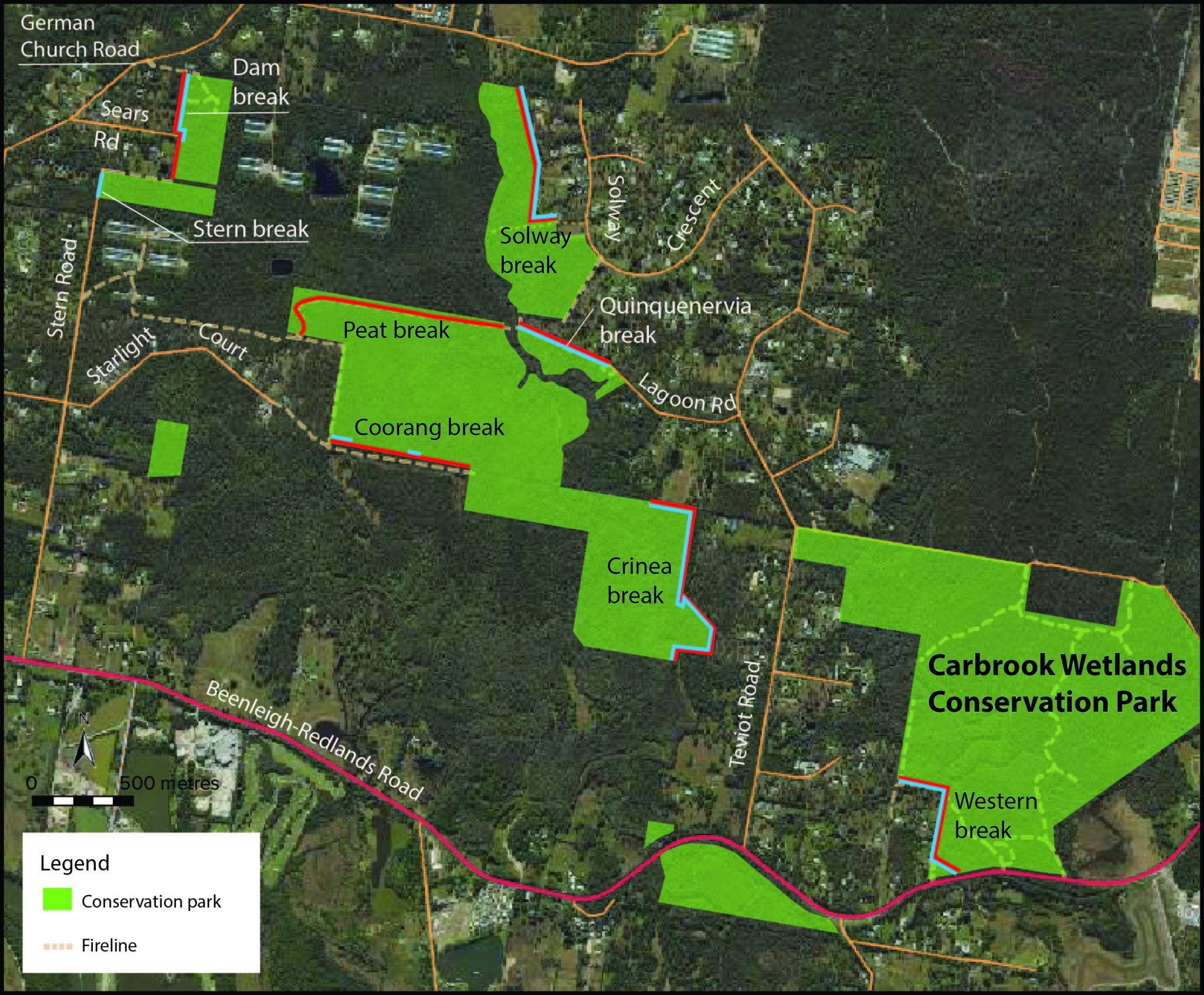
Carbrook Wetlands Conservation Park map with fireline upgrades indicated.
- Stern break—upgrade approximately 120m.
Vegetation management: remove understorey vegetation and debris along existing council road reserve and slashing understorey. - Dam break—upgrade approximately 297m.
Earthworks: widening required and hardening.
Vegetation management: slashing understorey and removing of regrowth vegetation, including stump grinding. - Solway break—upgrade approximately 715m.
Earthworks: minimal surface hardening.
Vegetation management: slashing and mulch regrowth understorey and widening fireline and remove fire hazard trees and stump grind.
Install approximately 86m of boundary fencing. - Peat break—upgrade approximately 816m.
Earthworks: surface hardening and install drainage.
Vegetation management: slashing of understorey regrowth vegetation. - Coorang break—upgrade approximately 289m.
Earthworks: surface hardening required to remove wheel ruts.
Vegetation management: selected removal of regrowth vegetation. - Quinquenervia break—upgrade approximately 395m.
Earthworks: approximately 395m of surface hardening and widening.
Vegetation management: removal of encroachment regrowth vegetation and stump grinding. - Crinea break—upgrade approximately 1243m.
Earthworks: surface hardening and widening approximately 600m (eastern side) and 145m (northern side).
Vegetation management: removal of trees, including stump grinding, and slashing of grassy understorey. - Western break—upgrade approximately 600m.
Earthworks: widening fireline and surface hardening near creek/wetland area as required.
Vegetation management: remove regrowth vegetation encroachment along the southern section approximately 392m, including stump grinding.
Install approximately 420m of boundary fencing.
Wolffdene section of Edward Corbould Nature Refuge
 Open larger image
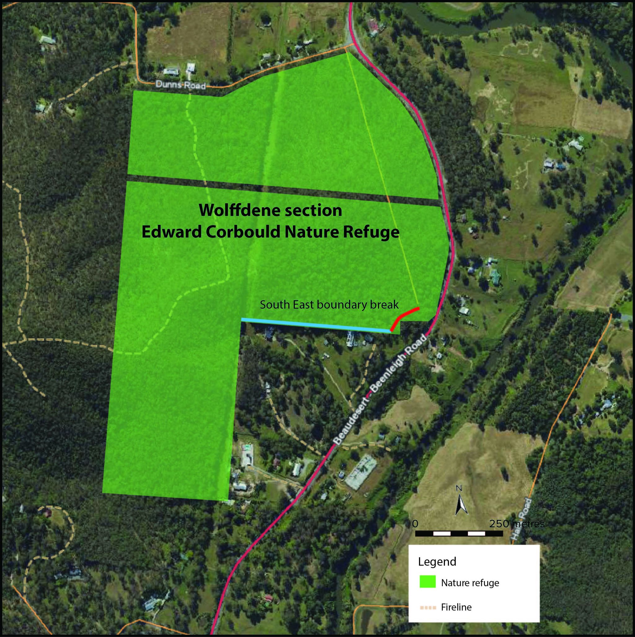
Wolffdene section - Edward Corbould Nature Refuge map with fireline upgrade indicated.
- South East Boundary break–upgrade approximately 500m.
Earthworks: repair minor rutting and reinstate whoa boys.
Vegetation management: widen break and remove regrowth vegetation and stump grind.
Strategic fireline specifications
| Requirement | Performance criteria | Specifications |
|---|---|---|
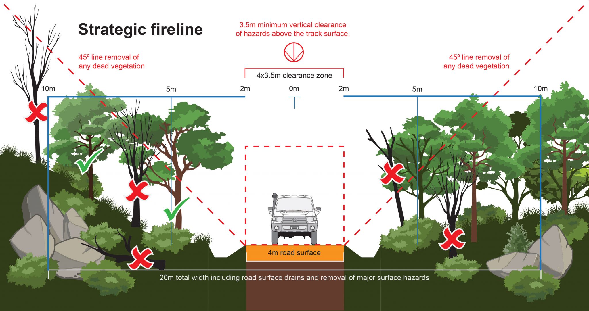
| Width | Ensure the road or track width provides for safe, dependable, and unobstructed passage by light to medium firefighting vehicles and plant/machinery within acceptable operational limits. | 4m wide trafficable surface (view diagram) except for short constrictions to 3.5m for no more than 30m in length where an obstruction cannot be reasonably avoided or removed. |
| Capacity | Ensure the road or track construction and formation ensures trafficability under most weather conditions (other than due to flood or storm surge) for light to medium firefighting vehicles (4WD) and plant. |
Road or track surface and crossing structures capable of carrying light to medium firefighting vehicles and plant — up to GVM 14t. |
| Surface clearance |
Limit fire movement across road or track.
Provide area of reduced fuel hazard. Limit likelihood of ignition of flammable fuels. Ensure removal or management of elevated and near-surface fuels, as well as major surface hazards to prevent access restrictions, minimise the risk of damage to light to medium firefighting vehicles and plant/machinery, and allow unimpeded access to fire appliances/equipment/machinery and maintain clear visibility. | Standard cleared width: The total cleared width for a fireline, including the road or track and any associated table drains, must not exceed 10m. Additional clearance for hazard reduction:
|
| Vertical clearance | Maintain a safe, dependable, and unobstructed passage for light to medium firefighting vehicles and plant/machinery, whilst ensuring a clear working corridor for staff to access equipment in vehicles and exit safely. | Minimum 3.5m vertical clearance above road/track surface clear of obstruction (view diagram). |
| Passing | Ensure road or track passing bay widths allow for light to medium firefighting vehicles and plant/machinery to pass safely at appropriate intervals. | Passing bays located where possible every 200–250m, 15–20m long and additional 3–5m wide in the passing bay section. |
| Turnarounds | Ensure the road or track allows for turning manoeuvres for light to medium firefighting vehicles and plant/machinery at appropriate intervals and /or at the road’s termination, enabling a return without obstructing the fireline. | Turnaround bays at least every 500m, e.g., at access points to properties (away from the hazard) and/or termination of road or track. |
| Bends/curves | Ensure road or track curvature allows for a clear and unobstructed view of the road or track ahead and facilitates the safe passage of light to medium firefighting vehicles and plant/machinery. | Curves with a minimum inner radius of 6m and outer radius of 12m. |
| Crew safety and fire control corridor | Ensure the fireline is designed and maintained to prioritise crew safety and effectively support fire containment efforts. | Remove:
Major surface fire control hazards including hollow logs or stumps and stacks, where practical, within 10m of the road or track verge. Stump obstacles within this area that cannot be removed are to be left visible (minimum height 1m) and permanently marked. Canopy trees, outside of the 6m trafficable surface, can be retained if they do not impede mechanical treatment, pose firefighter safety or control hazards, and have low or moderate bark hazard, i.e. non-flammable bark or regularly burnt bark (view diagram). |
| Signage | Ensure safety and orientation signs are permanently installed to facilitate safe navigation to and along the fireline from the nearest boundary access point and throughout the fireline. |
Signs located at strategic points to improve situational awareness and aid navigation during bushfire conditions.
Signs in place to identify supporting infrastructure (water points, bridges, heliports and landing areas, towers), passing bays, turnaround locations, one-way trafficable areas and dead-end points. |
Strategic fireline diagram
 Open larger image
Diagram showing requirements for a strategic fireline.