Things to do
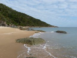
Walk or cycle to Shelly Cove.
Photo credit: Fiona O'Grady © Queensland Government
Camping and accommodation
Camping
Camping is not permitted in Cape Pallarenda Conservation Park.
Other accommodation
There is a range of holiday accommodation in and around Townsville. For more information, see the tourism information links.
Walking and mountain biking
The Cape Pallarenda trails are a network of shared walking and mountain biking trails in the Cape Pallarenda and Townsville Town Common conservation parks.
The trails range from short easy walks to challenging hikes and cross-country mountain bike rides. Consider your fitness level before undertaking the extended trails.
The give way code, Cape Pallarenda trails
The Cape Pallarenda trails are shared between walkers, runners and bike riders. Please be careful and courteous to all trails users and follow the shared trails give way code.
- Be alert for bike riders approaching from either direction.
- Cyclists must alert others when approaching.
- Everyone must slow down and go around wildlife.
Maps
- Cape Pallarenda trails map
- Cape Pallarenda Conservation Park map
- Townsville Town Common Conservation Park map
Trail descriptions
Shelly Cove trail
Distance: 750m one way
Time: allow 45min walking time; 10min riding time
Details: walkers and bike riders share this trail. Following an old access road created during World War II, this trail provides access to the beach at Shelly Cove on the northern side of the Cape Pallarenda headland. Large rock steps lead to the beach at the end of the trail. Trail users can return the way they came or continue along the Under the Radar trail.
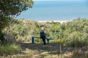
An afternoon sea breeze and stunning views across Rowes Bay are on offer along the Graves circuit walk.
Photo credit: Phil Copp © Queensland Government
Graves circuit

Distance: 2km circuit
Time: allow 1.5hr walking time
Details: starting 110m along the Shelly Cove trail, this circuit walk winds through woodland and vine thicket behind the Quarantine Station before returning along the Forts walk. Pass a weir built in 1925 and the graves of 13 people who died from meningitis at the Quarantine Station in 1920.
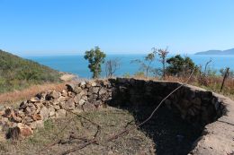
Find a WWII gun pit on the Forts walk.
Photo credit: Fiona O'Grady © Queensland Government
Forts walk
Distance: 500m one way
Time: allow 45min walking time
Details: this walk starts 290m along the Shelly Cove trail and leads up to several World War II gun emplacements and a searchlight station on Cape Pallarenda headland. Experience sweeping views of Townsville and Magnetic Island, return the way you came.
Under the Radar trail (UTR)
Distance: 10.1km one way
Time: allow 5hr walking time; 2.5hr riding time
Details: this narrow two-way trail is designed for cross-country mountain biking. Walkers and runners must stay alert for mountain bike riders approaching at speed from either direction – always give way to riders.
At its eastern end, the UTR trail begins 700m along the Shelly Cove trail and crosses the lower northern and western slopes of Many Peak Range. It provides excellent views of the islands to the north and the Coral Sea beyond. There is a link trail 6.6km along the UTR trail that leads to Smedley's trail. At its western end, the UTR trail begins 500m along the Shelly Beach trail in Townsville Town Common Conservation Park. The UTR trail has rough surfaces and some steep sections. Trail users can return the way they came or may use the other trails and internal conservation park roads to return to their starting point (see Cape Pallarenda trails map ).
Remember, follow the Parks and forests mountain bike and cycle with care and the walk with care guidelines.
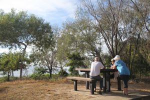
Enjoy a morning catch-up with friends or an afternoon picnic in the day use area.
Photo credit: Linda Thompson © Queensland Government
Picnic and day-use area
The Cape Pallarenda day-use area is located on the foreshore opposite the historic Quarantine Station. Enjoy panoramic view across to Magnetic Island. Picnic tables, water taps (treat water before use) and parking spaces are provided. Outdoor information displays describe the significance and history of Cape Pallarenda.
Fishing
Marine waters adjacent to Cape Pallarenda Conservation Park are internationally significant and are protected in the Great Barrier Reef World Heritage Area. Zones in the two marine parks, the Great Barrier Reef Coast and Great Barrier Reef, provide a balanced approach to protecting the marine and intertidal environments while allowing recreational and commercial use. Check zoning information and maps before entering or conducting any activities in the marine parks.
Fisheries regulations apply—information on bag and size limits, restricted species and seasonal closures is available from the Department of Primary Industries.
Be Crocwise. Learn how to Be Crocwise when fishing in crocodile habitat areas.
Viewing wildlife
The conservation park is home to many types of birds, wallabies and lizards that are easily spotted in the open woodland environment.
Read more about the natural environment of Cape Pallarenda Conservation Park.
- There are currently no park alerts for this park.