Frequently asked questions
The Moreton Bay Marine Park covers approximately 3,400km2 of tidal lands and waters stretching from Caloundra in the north to the Gold Coast Seaway in the south. It takes in most of the bay's tidal waters, including many river estuaries and extends seawards to the limit of Queensland state waters (i.e. three nautical miles).
Through the Marine Parks (Moreton Bay) Zoning Plan 2019, the Moreton Bay Marine Park aims to:
- protect and conserve, ecosystems, habitats, populations of marine species and genetic biodiversity, including internationally recognised wetlands and threatened species
- provide opportunities and access for ecologically sustainable use of the area including recreational, commercial, research and traditional activities
- The park has four different zones and eleven types of designated areas, classified according to the natural and/or cultural values of each area, with regulations covering recreational and commercial use.
Marine park zones
How is the marine park managed?
The Queensland Parks and Wildlife Service (QPWS) manages the marine park. Management activities include:
- conducting public education and interpretation
- monitoring critical flora and fauna
- encouraging and supporting scientific research
- undertaking assessments of various activities to occur in the marine park
- installation and maintenance of artificial reefs
- undertaking compliance and enforcement activities.
What can I do in a marine national park (green) zone?
Marine national park zones, commonly referred to as green zones, are ‘no take’ areas.
- They provide for protection of the natural integrity and values of the marine environment.
- Marine plants, animals or other resources cannot be removed from these zones.
- Low impact activities such as swimming, snorkelling, diving and boating are allowed.
- Travelling through a green zone with fish on board is permitted provided the fish were caught outside this zone.
All fishing or collecting equipment must be stowed or secured prior to entering a green zone.
Fishing or collecting equipment must be rendered inoperative and stored inboard the vessel.
How can I find out where the different zones are?
Zone boundaries are, where possible based on simple shapes with north/south and east/west bearings or natural features such as the edge of mangroves. Areas near the coast are aligned with landmarks where feasible.
To access and understand zoning locations and rules, you can:
- Download the free Marine Parks Southern Queensland app or QLD Fishing 2.0 app
- Download PDF maps – ensure you have a copy of the Moreton Bay Marine Park user guide .
- Access and download spatial data.
For more information visit Using the marine park app and maps.
I’m a recreational fisher. How many lines and hooks can I use in the different zones?
The marine park places no additional restrictions relating to line fishing in general use and habitat protection zones, to those restrictions in place under the fisheries legislation. Therefore, the restriction under the fisheries legislation that allows a maximum of 3 hand-held lines/rods per person and a maximum of 6 hooks/lures, apply in the marine park’s general use and habitat protection zones.
Conservation park (yellow) zones encompass significant marine environmental values in the marine park, where extractive use is limited. Up to two hand-held lines/rods per person and a maximum of two hooks/lures may be used when line fishing in the marine park’s yellow zones. This requirement matches Great Sandy Marine Park. Any fishing equipment that can't be used while in a conservation park (yellow) zone must be stowed and secured in the boat. Similar to a green zone this means the additional rods are in holders, or wholly inside the boat and the hooks are secured to the rod.
Restrictions on the number of lines and hooks are the same for both recreational and commercial line fishing in the marine park.
Fishing is prohibited in marine national park (green) zones. There is no limit to the amount of rods and fishing equipment you can have in your boat in a green zone as long as the rods are in holders, or wholly inside the boat and the hooks are secured to the rod. In other words, it should be obvious that the equipment is not being used. Check Fisheries legislation for any additional equipment restrictions.
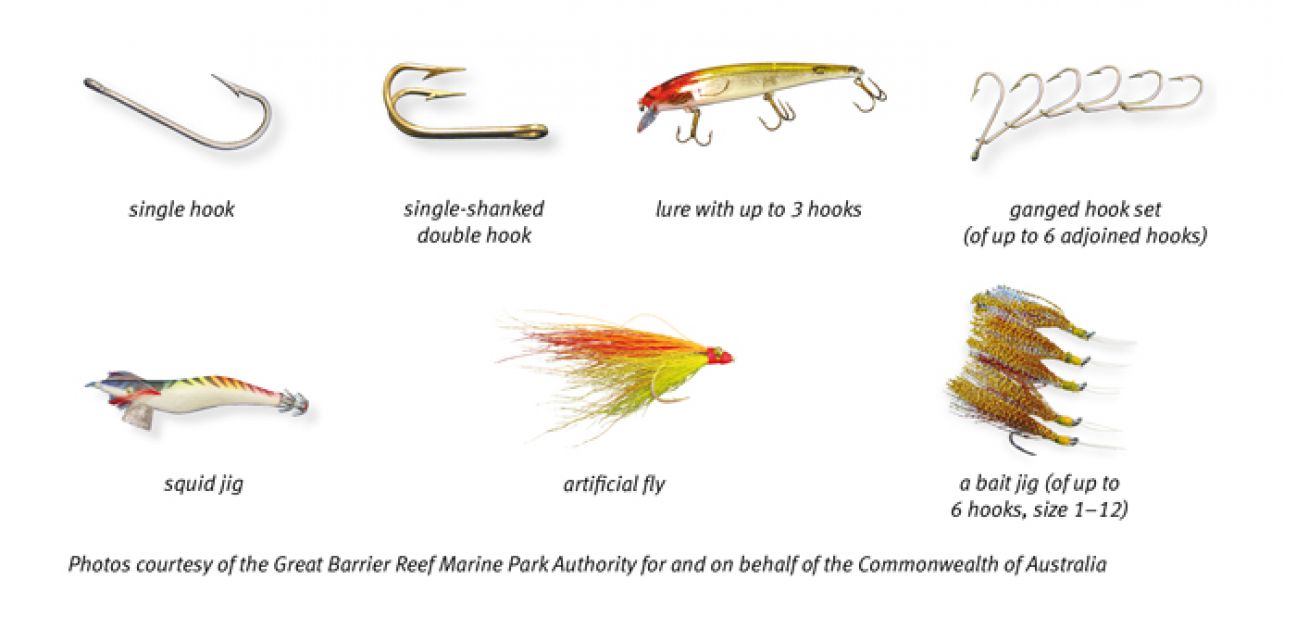
What is one hook?
A hook includes:
- a single-shanked hook
- a single-shanked double or treble hook
- an artificial lure with no more than 3 hooks attached to it
- an artificial fly
- a jig for taking squid
- a ganged hook set of not more than 6 hooks
- a bait jig that is a hook or group of not more than 6 hooks if each hook is between number 1 and number 12 size or equivalent
- a bait jig is a hook or group of hooks, of not more than 6 hooks, of a size between number 1 and 12 inclusively or an equivalent size.
How are commercial fisheries managed within the marine park?
All use of the marine park, whether commercial or recreational, is managed under the ‘entry or use provisions’ of the Moreton Bay Marine Park zones and designated areas. In relation to commercial fishing:
- Commercial trawling is only permitted in the general use zones.
- Commercial large mesh gill and tunnel netting is permitted in general use zones and habitat protection zones.
- Commercial line fishing is permitted in general use zones, habitat protection zones and conservation park zones (additional restrictions apply to the numbers of lines and hooks that can be used in conservation park zones).
- Commercial crabbing is permitted in general use zones and habitat protection zones. Limited crabbing restrictions apply in Conservation Park Zones.
- Commercial bait netting under the N11 fishery symbol is permitted in general use zones and habitat protection zones.
- Commercial bait netting is also permitted in conservation park zones, except for the taking of bream, flathead or whiting. To note, additional restrictions apply under the provisions Schedule 4, Div 2, Section 117 (1) of the Fisheries (Commercial Fisheries) Regulation 2019.
- The commercial ocean beach fishery can only be conducted in general use zones and habitat protection zones.
- The commercial collection of marine aquarium fish can occur in all zones with permission except marine national park zones.
I’m a native title holder. Can I fish and hunt in the marine park?
Section 211 of the Commonwealth Native Title Act 1993 provides for native title holders and the exercise of native title rights. In the marine park, native title holders are free to undertake traditional hunting, fishing, gathering, and partake in cultural or spiritual activities, for the purpose of satisfying their personal, domestic or non-commercial communal needs and in the exercise or enjoyment of their native title rights and interests.
Designated areas
What is the purpose of a go slow area?
- There are two types of go slow areas in the marine park – go slow areas that protect turtles and dugong from disturbance, injury or death caused by boats, and go slow areas that help to protect the natural integrity and values of relatively undisturbed areas in the marine park.
- In a go slow area for turtles and dugongs
- Vessels must not navigate on the plane in go slow areas.
- Vessels must not engage in motorised water sport activities, such as driving in a circular pattern, weaving, surfing across waves, waterskiing, tubing, parasailing.
- Vessels must not be operated in a way or at a speed that could reasonable be expected to result in striking a turtle or dugong.
- In a go slow area for natural values
- Vessels must not navigate on the plane in go slow areas.
- Vessels must not engage in motorised water sport activities, such as driving in a circular pattern, weaving, surfing across waves, waterskiing, tubing, parasailing.
- The rules do not apply in marked navigational channel in the Tripcony Bight – Long Island go slow area.
How will I know when my vessel is 'on the plane'?
The speed at which each vessel is ‘on the plane’ varies, but as a guide,
- a vessel is ‘on the plane’ when it is at a speed that allows the hull to travel over the top of the water rather than pushing through it.
Can commercial fishing vessels navigate on the plane in go slow areas?
No. All marine park users must navigate ‘off the plane’ in go slow areas, unless they are responding to an emergencyHow do depth contour boundaries work?For a 2m depth contour you must have at least 2m of water under the vessel at low tide and for a 5m depth contour you must have at least 5m of water under your vessel at low tide.
How can I find out where the designated areas are?
To access and understand designated area locations and rules, you can:
- Download the Marine Parks Southern Queensland app or QLD Fishing 2.0 app
- Download PDF maps ensure you have a copy of the Moreton Bay Marine Park user guide
- Access and download spatial data.
For more information visit Using the marine park app and maps.
What rules are in place to protect shorebirds from disturbance?
- Migratory shorebirds arrive on our shores early in summer and stay to the following autumn to roost, feed and replenish energy reserves for their return migration to the northern hemisphere.
- Throughout the marine park, general rules apply to protect shorebirds from disturbance by people, vehicles, vessels, aircraft and domestic animals.
- Disturbing shorebirds, causes them to take flight, wasting critical energy reserves needed to complete their migration successfully.
Collecting
What does ‘limited collecting’ mean?
Limited collecting means collecting by hand or using a hand-held implement that is not motorised, or pneumatically or hydraulically operated.
- A restrictions list applies—see ‘Restricted and excluded animals for fishing and collecting’ (Schedule 4 of the zoning plan. You can take (and have in your possession) no more than 2 specimens of the same species and no more than 5 specimens from this restrictions list).
- Limited collecting is allowed in all zones except marine national park (green) zones.
- Any collecting that does not fall under this definition requires a permit and can only be conducted in habitat protection (dark blue) zones and general use (light blue) zones.
Can I collect coral when I am visiting the Moreton Bay Marine Park?
No. The collection of coral for personal use, such as in home aquariums, is prohibited.
Anchoring
How long can I anchor in one place?
- Where there are no approved moorings, anchoring limits apply to prevent damage to seagrass, coral, and bottom-dwelling animals, and to manage pollution and vessel numbers.
- You must not anchor for more than 14 consecutive days or more than 30 days in any 60 day period, in the same place without a permit.
- A person must not anchor or moor a vessel or aircraft in the marine park for more than 120 days in any 12-month period.
Reporting illegal activities and injured wildlife
How do I report illegal activities?
- To report illegal fishing activity including fishing in a green zone contact FISHWATCH 1800 017 116.
- To report other illegal activity, marine incidents, and marine pollution contact 13 QGOV (13 74 68).
What should I do if I find a sick, injured, deceased or stranded marine animal?
- Contact the wildlife hotline on 1300 130 372 or notify us through the QWildlife App and note tag numbers if any.
- There are currently no park alerts for this park.
Get the app!
Zone and designated area information for the Moreton Bay Marine Park and Great Sandy Marine Park.
