Things to do

Girraween National park is a great place for walking.
Photo credit: Jolene Nelson © Queensland Government
Camping and accommodation
Camping
Camp at either Terrawambella, Kambuwal or Castle Rock camping areas. Walk-in bush camping is permitted in some parts of the park, subject to limits on numbers. Camping permits are required and fees apply.
- Find out more about camping in Girraween National Park.
- Book your camp site online.
- If you cannot book online, see camping bookings for other options.
Other accommodation
A range of holiday accommodation is available in and around Stanthorpe and Tenterfield. For more information see the tourism information links.
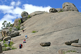
Walking up The Pyramid.
Photo credit: Jolene Nelson © Queensland Government
Walking
Girraween has 17km of walking tracks, ranging from a 280m stroll beside Bald Rock Creek to an 11km return walk to Mount Norman. Most walks start near the visitor information building and day-use area—except where indicated. Main tracks are well defined but expect rocky sections and steep upper slopes.
More experienced walkers with navigation skills can access an extensive fire trail network. A topographic map is required when using these remote tracks, none of which are described here.
Walking tracks at a glance
Matching experience and expectations—to make your planning easier, simply match your expectations and experience with the most suitable track or trail.
| Walk | Track name | Distance | Duration | Classification |
|---|---|---|---|---|
| Northern section walks | Wyberba Walk | 280m | 15min | Grade 2 |
| Granite Arch | 1.6km | 30min | Grade 3 | |
| Bald Rock Creek circuit | 2.2km | 1hr | Grade 3 | |
| The Junction | 3.7km | 1.5–2hr from camping area | Grade 3 | |
| The Junction | 5.2km | 2hr from day-use area | Grade 3 | |
| The Pyramid | 3.6km | 2hr | Grade 4 | |
| Eastern section walks | Dr Roberts Waterhole | 1.2km | 30min | Grade 2 |
| Underground Creek | 2.8km | 1–1.5hr | Grade 3 | |
| Southern section walks | Castle Rock | 5.2km | 1.5–2hr | Grade 4 |
| The Sphinx & Turtle Rock | 7.4km | 3–4hr | Grade 3 | |
| Mount Norman | 11km | 4–5hr from Visitor Centre | Grade 4 | |
| Mount Norman | 4km | 1.5–2hr from Mount Norman day-use area | Grade 4 |
Guided tours and talks
There may be ranger-guided walks and talks in holiday times. Contact the Girraween National Park visitor information building for more details.
Information
Spend time in the Girraween National Park visitor information building learning about Girraween's fascinating natural and cultural heritage, its wildflowers and dramatic landforms.
Picnic and day-use areas
Bald Rock Creek day-use area is next to the Girraween National Park Visitor information building, at the base of The Pyramid, 9km from the New England Highway. Toilets, picnic tables, electric barbecues and water are provided. It is recommended that visitors bring their own drinking water supplies.
Mount Norman day-use area can be reached by 2WD vehicles along unsealed Mt Norman Road about half an hours drive from Wallangarra. Pit toilets and picnic tables are provided, but water is not. Only 4WD vehicles may continue 12km north to meet with Pyramids Road.
Viewing wildlife
Girraween offers excellent opportunities for viewing wildlife. See kangaroos, possums and many colourful birds. Enjoy the colourful wildflower displays in spring.
With over 750 plant, 195 bird, 22 mammal, 23 frog and 45 reptile species, Girraween guarantees its visitors a close encounter of a natural kind.
See the description of the park's natural environment for more details about Girraween's diverse wildlife.
- Camping capacity reduced to minimise water consumption 6 October to 31 December 2026
- Swimming in Bald Rock Creek prohibited 18 September to 31 December 2026