Visiting Conway safely
Getting there and getting around
Conway National Park and Conservation Park are located on the Central Queensland coast, between Proserpine, Airlie Beach and Shute Harbour. Turn off the Bruce Highway just north of Proserpine, or 65km south of Bowen, then travel 26km to Airlie Beach.
To explore the coastal trails there are several options starting from Airlie Beach.
- Follow Shute Harbour Road southeast for about 7km to the Conway National Park day-use area.
- Follow Shute Harbour Road southeast for about 8km to the Swamp Bay car park.
- Follow Shute Harbour Road southeast for about 9.6km, turn left onto Whitsunday Drive follow this drive for approximately 1km to the Coral Beach car park.
To explore the highland trails on the Conway Range trail.
- From Airlie Beach travel southwest along Shute Habour Road for about 11km and turn left onto Brandy Creek Road. Follow this road onto Forestry Road through to the national park car park.
Contact the Department of Transport and Main Roads to find out about road conditions and the Bureau of Meteorology for weather reports and forecasts. Before you leave home check park alerts for the latest information on access, closures and conditions.
If you are planning to access the park's undeveloped southern end by boat, be aware that boating restrictions apply. See the Great Barrier Reef Marine Park Authority for further information.
Wheelchair accessibility
Toilets at the Conway day-use area are suitable for wheelchairs, some assistance may be required.
Staying safe
Conway National Park and Conway Conservation Park provide the opportunity to appreciate the natural, cultural and scenic values of this special area. To ensure your visit is safe and enjoyable please follow these guidelines.
- Plan carefully. Always let someone know where you are going and when you expect to return. If you change your plans, tell them. Carry plenty of water and snacks with you in case of an emergency.
- Be realistic about your walking and cycling ability. Ensure you have enough daylight. Plan to finish your walk or ride well before dark.
- Be careful near cliff edges and viewpoints. Stay behind lookout fences.
- Night-time temperatures can drop to 2 degrees during the cooler months, so plan accordingly.
- Carry at least one form of communication equipment. Satellite phones and Personal Locator Beacons (PLBs) are the most effective in this area. Mobile phone coverage is unreliable. There is patchy coverage around the Mount Rooper area, the Forestry Road carpark and occasional coverage from the ridgelines between Mount Hayward and Airlie Beach on the Conway Range trail.
- Wear appropriate walking and cycling safety gear. Be sun-smart and wear a hat, long sleeved shirt and sunscreen. Cover up to protect yourself from scratches, bits and stings.
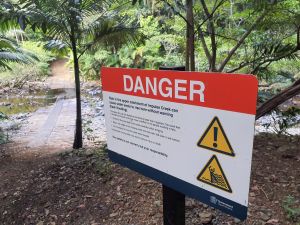
Heed all safety warnings, and take care at all creek crossings on the Conway Range trail
Photo credit: © Queensland Government
- Read and heed all safety and access warnings. Trails may be closed at times due to severe weather or management operations.
- Treat all water you take from tanks, creeks and taps before drinking.
- Be prepared to encounter wildlife. Snakes, spiders, stinging plants, leeches, ticks and insects are common, so know how to respond. Remember, all wildlife is protected.
- Do not underestimate the relentless heat and high humidity of the ‘build up’ (October to December), or the heavy rainfall of the ‘wet season’ (January to March). Severe weather and flash flooding are more likely during this period.
- Take care around creeks. Avoid sharp and loose rocks at creek crossings.
- Do not attempt to cross creeks when flooded. During and after heavy rain, creek conditions can change and become very dangerous. Fast flowing, rapidly rising water can occur. To stay safe, do not enter the water.
- Severe weather and cyclones are common along Queensland's tropical coastline. Never go walking or cycling during or after severe weather or a cyclone. Check weather forecasts before you visit.
- Take care on the beach. Lifesavers do not patrol Coral Beach or Swamp Bay. Visitors to the Whitsunday area are reminded to be SharkSmart on beaches and the coastline in and around the parks.
- Protect yourself from marine stingers, especially from October to May, although some may be present year-round. See marine stingers for more information.
- Be aware that estuarine crocodiles sightings have occurred in the coastal waters around the parks. Remember—always Be Crocwise in Croc Country.
Please follow the Parks and forests stay safe and visit with care guidelines.
In an emergency
For all emergencies, phone Triple Zero (000).
For more information, please read the guidelines on safety in parks and forests.
Before you visit
Opening hours
Conway National Park and Conway Conservation Park are open all year around. Sections of parks may be closed at times due to severe weather or management operations. Check park alerts for the latest information on parks and forests access, closures and conditions.
Essentials to bring
- A first-aid kit and reliable communications equipment.
- Drinking water—all creek and tank water needs to be treated before drinking. Tank water may not be available. There is no reliable water source in the park.
- Fuel stove and fuel—fires are not permitted.
- Sealable rubbish container—bins are not provided.
- Insect repellent.
- Sun protection—some areas of the parks are quite exposed.
Permits and fees
Camping permits
If you intend to camp you will need to obtain a camping permit and fees apply. A tag with your booking number must be displayed at your camp site. Penalties apply for camping without a permit.
- Book your camp site online.
- If you cannot book online, see camping bookings for other options.
Other permits
Various activities conducted in Conway National Park and Conway Conservation Park may require a permit. These activities include commercial tours, social events (such as weddings), organised group visits, school excursions, scientific research, and sale of photographs or vision of Conway National Park and conservation parks. View permits and fees for further information.
Climate and weather
The region has a well-defined dry season in winter, with average temperatures of 10–20°C. Between January and March, high humidity, strong seasonal rainfall and average temperatures of 20–35°C make conditions less comfortable. Weather forecasts are available from the Bureau of Meteorology.
Pets
Dogs and other domestic animals are not permitted in Conway National Park or Conway Conservation Park.
Fuel and supplies
The nearest fuel and supplies are located near Airlie Beach or at Proserpine (18km).