Seagrass
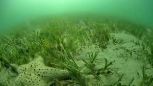
Seagrass
Photo credit: © Science Under Sail Australia
Seagrass meadows form one of the most widespread marine habitats occurring in estuarine and coastal waters across every continent except Antarctica.1
These unique marine plants share a similar structure to terrestrial (land) plants, featuring small flowers and strap-like or oval leaves. Unlike seaweeds, which are a type of algae, seagrasses are more closely related to lilies. Seagrasses establish in estuaries and shallow coastal areas with sandy or muddy seabeds, forming vital underwater meadows. To thrive, seagrasses require sunlight, clear water and nutrients.
Under the Fisheries Act 1994, all seagrasses—whether living or dead—are protected to ensure their conservation and the health of marine ecosystems. Seagrasses within the Moreton Bay Marine Park are also protected under the marine park’s zoning plan. This protection is achieved through specific zoning measures, such as green and yellow zones, which prohibit certain fishing activities like trawling. Additionally, special management strategies are in place, including designated no anchoring areas to prevent physical damage to sensitive habitats caused by anchors. Designated go-slow areas also help protect seagrass beds by minimising potential harm from vessel motors.
Read more about the ecology and value of seagrass.
Seagrasses of the Moreton Bay Marine Park
There are over 70 species of seagrass worldwide, half of which are found along Australia’s coastline. The Moreton Bay Marine Park hosts seven of these species which represent three of the four seagrass families found in subtropical coastal waters. 2
- Halophila ovalis
- Halophila decipiens
- Halophila spinulosa
- Zostera muelleri
- Cymodocea serrulata
- Halodule uninervis
- Syringodium isoetifolium
The distribution of seagrass in Moreton Bay Marine Park is primarily determined by the amount of sunlight that reaches the sea floor which in turn depends on the turbidity (or murkiness) of the water. In the western bay where the water is more turbid, seagrass is restricted to intertidal and shallow subtidal areas where only six percent of the surface light reaches the sea floor, which is just enough for this species to survive.3
Seagrass plays a critical role in the health of the Moreton Bay Marine Park. It provides habitat for many marine park species and is the primary food source of dugong and some marine turtle species.
Seagrass management project
The department secured funding from the joint Australian-Queensland government funded Disaster Recovery Funding Arrangements Environmental Recovery Program to examine the effects of the 2021/2022 severe weather events on seagrass.
To support this initiative, the Queensland Parks and Wildlife Service engaged Science Under Sail Australia to conduct surveys and research into the impacts and resilience of seagrass in Moreton Bay Marine Park. The research aimed to better understand the effects of the 2022 fooding events on seagrass and its capacity for recovery.
Background
- The 2022 flood events had a significant impact on the Moreton Bay Marine Park, with large volumes of freshwater, sediment, and nutrients entering the ecosystem.
- Seagrasses are particularly vulnerable to flood events due to factors such as freshwater stress, sediment smothering, increased sediment and nutrient levels reducing water clarity, algal growth limiting light availability, toxicants hindering plant growth and physical damage caused by flood debris.
- The recovery of seagrass depends on its condition prior to the disturbance (e.g., size of seedbank reserves and availability of fragments) and the duration and intensity of the event (e.g., sediment resuspension caused by tidal flows and wave action).
- Extensive seagrass surveys had not been conducted in Moreton Bay since 2011.
- To assess the impacts of the 2022 flooding event and monitor seagrass recovery, surveys were carried out at intervals one year post flood and two years post-flood.
Summary of project findings
- Compared to the pre-flood (2015-2021) seagrass extent (327km2), the area of seagrass declined by 7 percent in the first year (2022-2023) post-flood (304km2) which increased to 10 percent the second year (2023-2024) post-flood (292km2).
- The observed depth range of all seagrass species declined post-flood, indicating that seagrass loss is most likely a consequence of flood-induced benthic light restriction.
- Despite an overall reduction in extent, seagrass recovered in many intertidal locations and exceeded the pre-flood extents in some meadows, however, there was limited recovery in deeper meadows suggesting elevated turbidity and low light availability continues to limit seagrass recovery.
- Seagrass meadows located on the southern (i.e. Southern Bay and Broadwater) and central-western (i.e. Waterloo Bay) side of the bay showed some resilience to flood impacts, maintaining the majority (93-99 percent) of their pre-flood extent.
- The Eastern Bay area, which harbours the highest diversity of seagrass species, demonstrated the greatest decline, particularly within deep subtidal meadows.
- Declines in the deep subtidal areas of Deception Bay and all depth zones of Bramble and Central Bay were also identified.
- Considerable seagrass loss (31 percent) in the Pumicestone Passage since 2002, with the majority of loss occurring within the Tripcony Bight area.
- Species shifts were recorded in deep subtidal meadows resulting in an increase in the dominance of Halophila ovalis.
- Intertidal meadows containing Zostera muelleri / Halodule uninervis with Halophila ovalis and Halophila spinulosa were the most resilient to flood impacts.
- Despite evidence of partial recovery of H. spinulosa meadows, this continues to be the species most affected by the 2022 flood event, particularly in deep subtidal meadows.
- The decline in H. spinulosa, Cymodocea serrulata and Syringodium isoetifolium in some meadows may signify a potential shift towards more transitory coloniser meadows, particularly in the deeper habitats.
- Observations of biomass and seed abundance in Moreton Bay support the notion that seagrass meadows are resilient and showing signs of recovery following the 2022 flood.
- Further seasonal recovery is expected with favourable growing conditions and the absence of major flooding.
Project reports
August 2023-January 2024 Monitoring Report
Read the full report: Seagrass distribution within Moreton Bay Marine Park: Seagrass response to the 2022 flood .
October 2022-January 2023 Monitoring Report
Read the full report: Impact of the 2022 flood on the seagrass habitats of Moreton Bay Marine Park: Post-flood survey Spring/Summer 2022/23 .
Note: The August 2023-January 2024 report analysis method differed to that of the October 2022-January 2023 report to improve accuracy. This resulted in altering the percentage changes initially reported.
References and further reading
- Green, E.P. and Short, F.T. (2003) World atlas of seagrasses, University of California Press
- Waycott, M., McMahon, K., Mellors, J., Calladine, A. and Kleine, D. (2004). A guide to tropical seagrasses of the Indo-West Pacific, James Cook University, Townsville.
- Udy, J. and Levy, D. (2002). Deep seagrass and coral habitats found in Eastern Moreton Bay, University of Queensland, Brisbane.
Maxwell, P., Connolly, R., Roelfsema, C., Burfeind, D., Udy, J., O’Brien, K., Saunders, M., Barnes, R., Olds, A., Hendersen, C. and Gilby, B . (2019). Seagrasses of Moreton Bay Quandamooka: Diversity, ecology and resilience. In: Tibbetts IR, Rothlisberg PC, Neil DT, Homburg TA, Brewer DT, & Arthington AH (Eds). Moreton Bay Quandamooka & Catchment: Past, present, and future. The Moreton Bay Foundation. Brisbane, Australia. Available from: https://moretonbayfoundation.org/
Smart, J.N., Hammerman, N.M., Golding, K.M., Markey, K., Kovacs, E. and Roelfsema, C. (2025). Decadal monitoring shows seagrass decline and community shifts following environmental disturbance in Moreton Bay, south-eastern Queensland, Australia. Marine and Freshwater Research 76, MF25049. doi:10.1071/MF25049
- There are currently no park alerts for this park.
Get the app!
Zone and designated area information for the Moreton Bay Marine Park and Great Sandy Marine Park.
